![]()
![]()
![]()
![]()
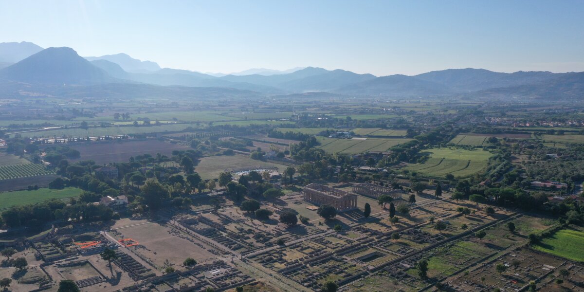
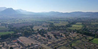
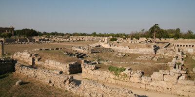
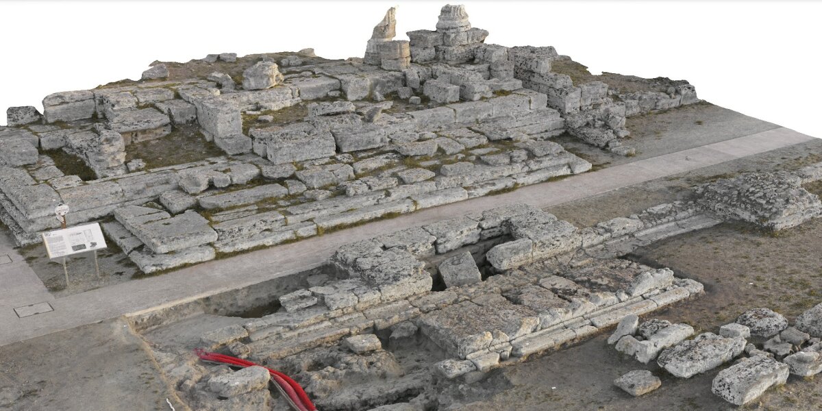
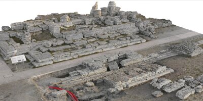
The Roman forum at Paestum is home to the comitium and temple complex, two buildings that have been accorded the highest importance in research into the architecture and urbanism of Republican colonies. This is partly due to the very well-preserved features and finds from the area, but also to the numerous unusual elements of these two complexes. To this day, neither the exact reconstruction of the temple, nor its cult or its exact dating have been clarified beyond doubt and with complete conviction. Furthermore, parts of the old finds have so far only been presented incompletely. Due to its architectural ornamentation, the combination of Doric and Corinthian order and the Corinthian capitals, the temple plays a central role in the development of Middle to Late Republican architecture in Italy.
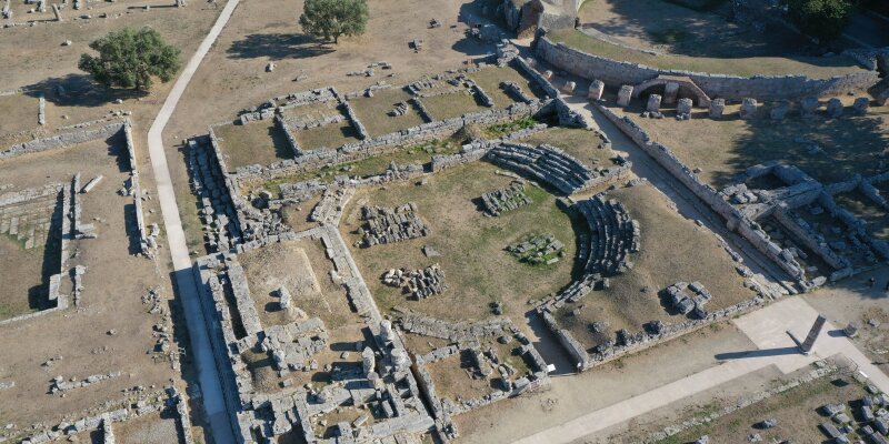
No less significant is the comitium, which in its preservation is one of the most important representatives of this architectural type in the Roman colonies. What is highly unusual is the strange-looking incision of the forum temple into the stepped circle in the comitium, which on the one hand intervenes with its podium in the assembly circle and on the other hand lies on the western entrance area (so far only hypothetically reconstructed). While the construction of the comitium was still associated with the beginning of the Roman colony, the dating of the temple varies between the 4th and early 1st century BC - it has therefore been repeatedly debated whether the temple is older, younger or contemporaneous with the comitium.
The long-term aim of the project is to resolve the discrepancies in the dating of the complex in previous research, to finally record the associated material and the building ornamentation in full and to gain a clearer, possibly new picture of the complex. This could make it possible to finally determine one of the most important temples of the Hellenistic period in Italy as a secure fixed point.
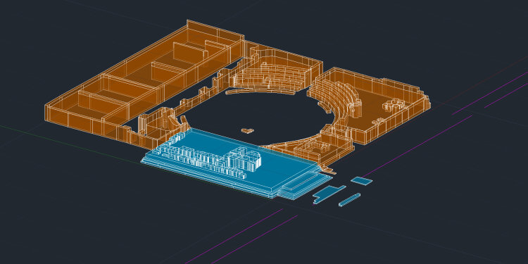
The initial preparatory work served to verify the results of older building surveys and to carry out a current inventory check. To this end, the forum stamp, individual structural elements and sections of the Comitium were re-measured and a measurement cloud was created for a working model in AutoCAD. In addition to a photographic documentation of the current condition, the architectural elements and the previously unpublished ceramics from the museum's depot were also recorded. It turned out that, on the one hand, the pottery from the area around the temple cannot be dated to any later than the 3rd century BC and, on the other hand, significantly more structural elements have been preserved for the reconstruction than previously published. In addition, numerous important details of the ornamental and metope blocks, in particular the course of their butt joints or the backs, were not taken into account in the reconstructions presented to date.
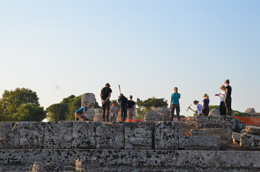
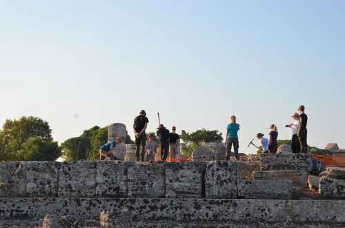
As part of a second campaign, new excavations were carried out in areas of the temple that had not previously been investigated. A teaching excavation project was chosen as the format, as the remains of the temple gave students the opportunity to participate in all typical areas of a Mediterranean archaeological excavation and gain extensive experience. It quickly became apparent that after the first layers of humus had been removed, almost the entire inner area of the podium (cella and eastern pteron) still had the undisturbed mortar-like backfill, which had been placed in various stages and could be clearly distinguished stratigraphically. A small part of these layers in the eastern Pteron was excavated. In particular, these layers were uncovered in the cella foundation and on the east side of the temple, where the complete grid foundation had never been documented before. Here, the blocks of the podium had been massively robbed in the Middle Ages - probably as part of the new Norman buildings in Salerno. In addition to the earth, the associated robbery trench backfill was largely interspersed with building material from the temple.
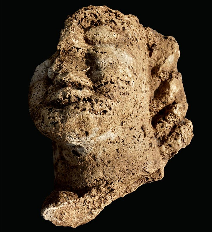
At the same time, two older sections were reopened to check the stratigraphy and the entire temple was cleaned for a laser scan. The results are already extremely promising: on the one hand, the investigations of the backfill provided many insights into the ancient construction process of the podium. In addition to various concentrations of chippings, impressions of ancient installations in the backfill can also be mentioned here. On the other hand, it turned out that the altar in front had a predecessor phase in a slightly inclined position. Several other fragments of ancient building ornamentation - including the archaizing head of one of the head capitals - were also recovered and numerous fragments of two floors made of opus signinum and monochrome tesserae were found.
After a break due to the coronavirus pandemic in 2020, work continued in 2021. The excavations were concentrated on the north-eastern transition from the temple to the comitium and the western altar zone. First of all, it was possible to prove that a massive drainage layer inside the comitium circle was probably related to the construction of the comitium in the 3rd century BC and should not be dated to the archaic period as previously postulated. At the same time, despite the numerous interventions in the 1930s, 1950s and 1980s, undisturbed remains of the stratigraphy could be recognized at the podium foundation. The observations here suggest a two-phase nature of the foundations: one phase before and one after the construction of the podium. It also emerged that the younger part of the podium was underpinned with the spolia of an older, lowered architecture. Components of careful profiling were found here as the lowest foundation layer.
In the altar zone, there is increasing evidence that the large water basin in front of the altar may be of older origin than previously assumed, and at the same time may have been closely connected to the altar and thus also to the cult of the temple due to its dimensions. However, this zone has been particularly disturbed, both by recent excavations and by medieval interventions. An early medieval burial was found here, which matches other graves from the area around the forum.
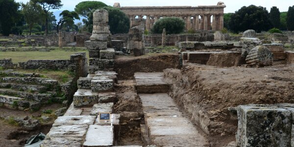
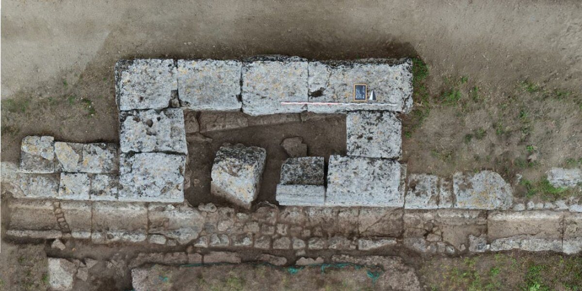
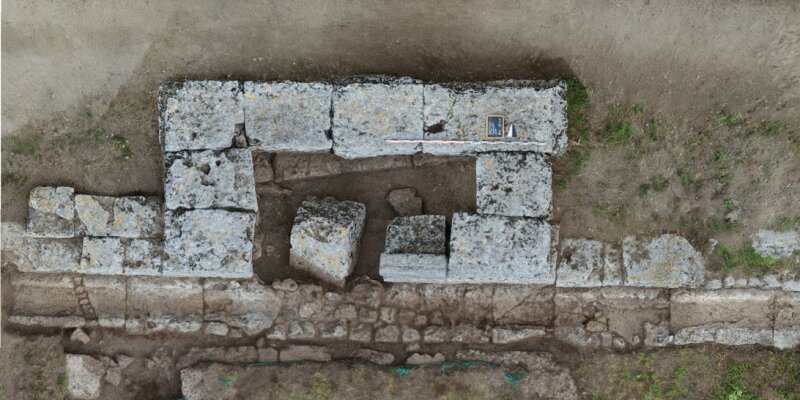
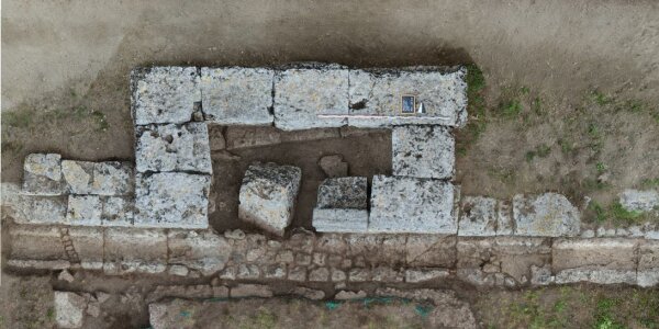
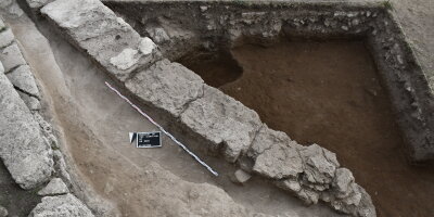
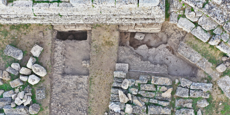
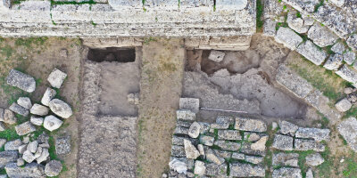
Two sections were created in the 2023 campaign.
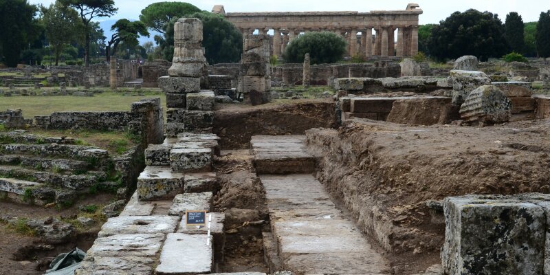
Section 7 focused on the interior of the comitium directly in front of the cavea in the north-east. Here, the entire bottom row of steps was first cleaned and uncovered. The remains of several running horizons are still in situ directly below the round of steps of the cavea. These consist of rammed earth heavily interspersed with lime and broken pottery. Almost all of these superimposed soils were cut through during the construction of the cavea in order to fit the lowest layer of steps. The construction of the wall in the north, which is interpreted as part of a raised portico in front of the curia, is also striking. In the eastern part, it was placed directly on the younger walking horizon, while a further block layer (euthynteria) exists further west. Remains of the ancient drainage system were also found inside the comitium, which fits in well with the findings of recent years on the west side of the comitium (cf. 2021/2022 campaign).
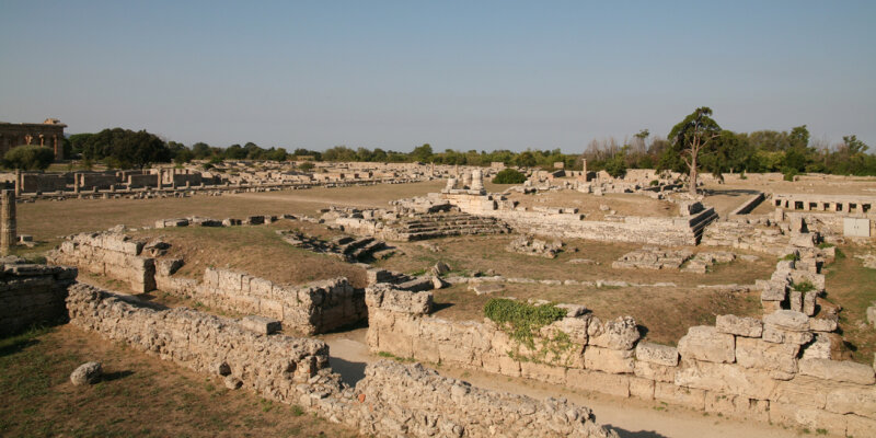
Section 8 was set up along the outside of the temple and comitium, bordered to the west by the temple's flight of steps and to the east by Greco-Theodorescu's section 66. Here, too, a clear sequence of different running horizons was excavated in the area of the forum square, which were similar in composition and followed each other relatively closely. The lowest horizon was perforated in many places: in particular, postholes of different dimensions were found, as well as a rectangular hole directly in front of the temple podium. The largest postholes, which run in a line through the southern end of the cut, are striking. A more precise dating is not yet possible, as the feature has not yet been excavated. However, the soil is certainly older than the temple and also than the wall of the comitium, as it was pierced with a foundation trench when the comitium wall was built. A water pipe also came to light in the northern part of the cut. It consists of elongated blocks into which the canal was sunk and appears to go under the comitium wall in the east.
One sub-project is the systematic re-recording of all components as well as the additional documentation of all objects of the building ornamentation using the Structure from Motion method. To this end, all of the temple's components were cleaned, described, drawn and then photographed, and the finished models were then assembled and reconstructed on the computer. It soon became clear that the main ideas of the older reconstructions could no longer be maintained and that a new reconstruction seemed promising.
In the 2023 campaign, the metopes in particular were further documented. Further photographs were taken of them, especially of the upper and lower sides. At the same time, the rear profiles of the metopes were documented in drawings in order to better understand the differences in their design.
J. Albers – A. Bertelli – C. Haubenthal – L. Latzel – Th. Schapals – M. Rimböck – B. Weissová – C. Widow, Der korinthisch-dorische Tempel und das Comitium am Forum von Paestum. Die Kampagnen 2017, 2019, 2021, AA 2023, eingereicht
J. Albers – C. Widow, Il Tempio al Foro di Paestum, Nuovi Scavi 2019, in: E. Greco (Hrsg.), Fenomenologia e interpretazioni del rito. IV Convegno Internazionale, Paestum 2019, DialArchMed 2019.2, 23–31
J. Albers – C. Widow – M. Rimböck – Th. Rafflenbeul, Der korinthisch-dorische Tempel am Forum von Paestum. Die Grabungskampagne 2019, KuBA 8, 2019, 53–64
Prof. Dr. Jon Albers
Professor für Klassische Archäologie mit dem Schwerpunkt Siedlungen und Landschaften im antiken Mittelmeerraum
Institut für Archäologische Wissenschaften
Ruhr-Universität Bochum
Am Bergbaumuseum 31, 44791 Bochum
Raum: 0.3.2
Tel.: (0234) 32-28528
Mail: jon.albers@rub.de
Claudia Widow M.A. (auch Schnittleitung und Bauornamentik)
Institut für Archäologie und Kulturanthropologie
Universität Bonn, Am Hofgarten 21, 53113 Bonn
e-mail: cwidow@uni-bonn.de
Dr. Anna Bertelli
Institut für Archäologische Wissenschaften
Ruhr-Universität Bochum, Am Bergbaumuseum 31, 44791 Bochum
Tel.: 0234 / 32-19232
e-mail: anna.bertelli@rub.de
ehemalig:
Ehemalige Schnittleitung
Clarissa Haubenthal M.A. (2021)
Anna-Lisa Schneider B.A. (2022)
Dr. Barbora Weissová (2021)
Marc Klauß B.A. (ab 2022)
Miriam Rimböck M.A. (2017/19)
Theresa Rafflenbeul M.A. (ab 2021)
Dina Schwarz M.A. (ab 2023)
Hanna Merk B.A. (ab 2023)
Lucas Luigi Latzel M.A. (2019-2022)
Claire Dohmen B.A. (ab 2023)
Florian Birkner, Stefanie Herten, Stefanie Holzem (Vermessung), Annabelle Walter, Ferdinand Wulfmeier
Antonia Becker, Georgy Chekalov, Lina Etzelmüller, Anna Jochheim, Jan-Philipp Lenk, Jakob Matyschok, Leonie Nolte, Svenja Oebel, Tim Teufel, Johannes Todtberg
Eireen Bachmann, Stella Becker, Johanna Brenneke, Claire Dohmen, Lilly Eckhoff, Jan-Philipp Lenk, Sophie Peintinger, Tim Teufel und Věra Doležálková (Zeichnerin)
Damaris Axmann, Sina Blecher, Claire Dohmen, Lennart Fütterer, Bejamin Gronwald, Hanna Merk, Simon Prinz, Nicola Reß, Ira Victoria Schwabenland, Dina Schwarz, Tim Teufel, Kader Tokul, Jonas Tilahun, Stefan Ullrich, und Fee Wirges
Talina Albrecht, Margarida Alvega Cerejo, Sarah Fabienne Beermann, Lilly Johanna Eckhoff, Cara Felicia Klein-Raufhake, Zakary Storm Müller, Niklas Packlin, Nicola Reß, Lara-Maria Schneider, Enya Schröer, Niklas Schuller, Sarah Schulte, Dina Schwarz und Anja Wolf
Copyright © ArchWiss 2025
Last update: Jan 27, 2025


